Short Bio
I am now a master’s student in the Faculty of Geographical Sciences, Beijing Normal University (top 3 subject ranking in China). Under the supervision of Prof. Jin Chen, my previous research mainly focused on agricultural remote sensing, including data quality improvement for agricultural regions and crop mapping. I aim to integrate multi-source remote sensing data, to study the interactions between agriculture and food security, water conflicts, and global climate.
Prospective PhD Student
I am currently looking for a Ph.D. position starting in 2024 Fall, related to remote sensing, agriculture, food security, global climate, ecosystems, earth systems, plants, and forests.
[CURRICULUM VITAE]
My Strengths
- Rich experience in remote sensing: Proficient in satellite data processing & analysis through programming and professional software.
- Scientific research training: Completed one first-author paper, accepted by Remote Sensing of Environment (SCI, IF=13.5).
- Solid Geography background: Explored various branches of geography with high GPAs, including physical geography (e.g., ecology, climatology) and human geography (e.g., economic geography, urban geography).
- Active and fast learner: Constantly stepping out of my comfort zone with broad experience in phenology, deep learning, etc.
📖 Educations
- M.D. Faculty of Geographical Sciences, Beijing Normal University (BNU), Beijing, China $~~~~~~~~~~~~~~~~~~~~~~~~~~~~~~~~$2021 - present
- Major in Cartography and Geography Information System $~~~~~$ Supervisor: Dr. Jin Chen
- B.S. School of Geography and Planning, Sun Yat-Sen University (SYSU), Guangzhou, China $~~~~~~~~~~~~~~~~~~~~~~~~~~~~~$2017 - 2021
- Major in Geographic Information Science $~~~~~$ GPA: 4.0/4.0 (Rank 1/61)
📑 Publications
- Gu, Z., Chen, J., Chen, Y., Qiu, Y., Zhu, X., & Chen. X. (2023). “Agri-Fuse: A novel spatiotemporal fusion method designed for agricultural scenarios with diverse phenological changes”. Remote Sensing of Environment, 299, 113874. https://doi.org/10.1016/j.rse.2023.113874
📝 Research Experience

Agri-Fuse: A novel spatiotemporal fusion method designed for agricultural scenarios with diverse phenological changes
Synthesized remote sensing images with high spatial and temporal resolution, especially for agricultural regions with diverse phenological changes.
- Background: Previous data fusion methods that synthesize high-quality remote sensing data fail to reconstruct high-spatial-resolution images of key phenological periods in agricultural scenarios.
- Methodology: An innovative algorithm, Agri-Fuse, was developed to highlight phenological change information for the first time.
- Results: Outperformed three benchmarks and one state-of-the-art algorithm, and improved the overall accuracy of crop classification from 88% to 92%.

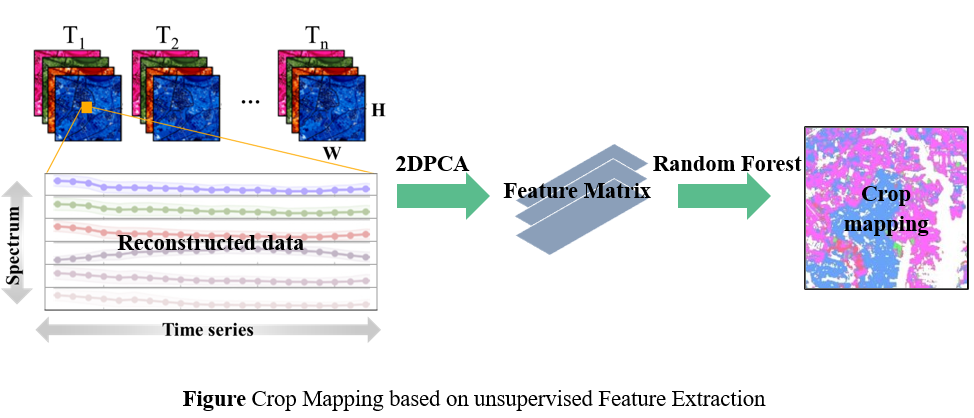
A Crop Classification Framework with Data Reconstruction and Feature Representation Using Sentinel-2 and Sentinel-1 Time Series
Extracted representative features from reconstructed gap-free Sentinel-2 optical time series for better crop classification
- Background: The high-dimensional characteristic of multispectral time series data requires large training samples, which limits the performance and transferability of the crop classification algorithm.
- Methodology: Adapted a Two-dimensional Principal Component Analysis to improve data representativeness for better crop classification.
- Results: Achieved an outstanding 90% overall accuracy in mapping major crops in both northern and southern China with a random forest classifier, ranking 2/600 teams in a national mapping contest.
📚 Other Professional Experience
- Conference Presentation, The 30th International Conference on Geoinformatics, London, UK, 2023
- Project Cooperation, National Rice Irrigation System Type Mapping Using Fine-Resolution Imagery and Deep Learning Modeling, University of California, Berkeley, 2023
- Teaching Assistant, Introduction to Remote Sensing (3 credits), BNU, 2023
- Field Survey, National Crop Planting Survey, BNU, 2022 - 2023
🛠️ Skills
- Programming Language: Python (Advanced), Matlab (Advanced), IDL (Intermediate), R (Intermediate)
- Professional software: Google Earth Engine, ENVI, ArcGIS, SNAP, LESS, SPSS, EndNote
- Languages: Fluent in Mandarin (Native) and English (TOFEL: 104)
🎖 Honors and Awards
- First-class scholarship (Top 1% granted by BNU, 2021)
- Outstanding Undergraduate Thesis (Top 1% granted by SYSU, 2021)
- Top Ten Outstanding Graduates (Top 1% granted by SYSU, 2021)
- First-class scholarship (Top 1% granted by SYSU, 2020)
- National Scholarship (Top 1% granted by the Ministry of Education of China, 2018)
💬 Know More About Me

- I am a sports enthusiast with a passion for basketball and tennis
- I am an explorer with a preference for the harder road.
